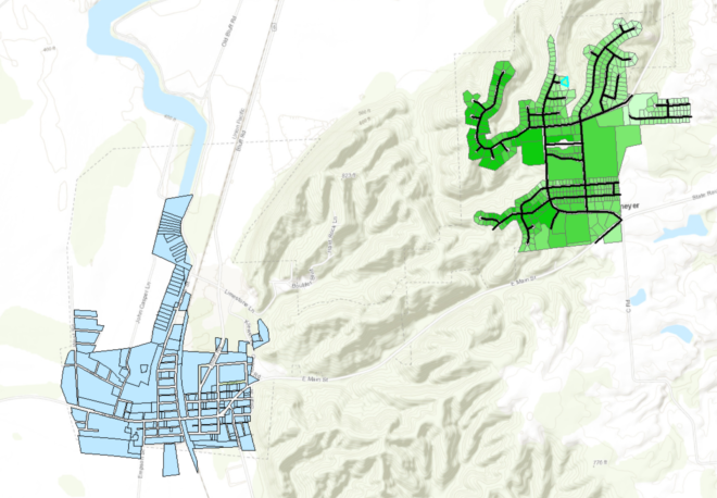
In this course, Data Formats Design and Quality, our project centered on the doing some GIS work as if we were working in the assessor's office planning for the physical move of the town of Valmeyer, Illinois. The original town (in blue) was down in the flood plain of the Mississippi and they experienced repeated loss of life and property. They decided to move the WHOLE town to a safer elevation.
I was given the old and new property parcel information and was tasked with adding the mean, minimum, and maximum elevation for each new parcel and the mean, minimum, and maximum slope for each new parcel. I also needed to calculate the mean distance from the old town to the new town. Lastly, I was to create new line objects for the roads in the new town. The results from all this analysis were to be provided as a public web map. (see the finished map at https://arcg.is/1OvSzr )
The following steps were used in the analysis:
- In the Catalog I created a new layer containing polylines for the roads
- Using the editing tools I created new line objects for the roads
- Using the zonal statistics by table tool to create a table of elevations for each parcel in new Valmeyer layer
- Removed unnecessary fields and renamed the fields in the table from ArcCatalog
- Table join on the new Valmeyer parcels to join the mean, min, and max elevation
- Using the slope tool, I added mean, min, and max slope to create a slope raster
- Using the zonal statistics by table tool to create a table of slopes for each parcel in new Valmeyer layer
- Removed unnecessary fields and renamed the fields in the table from ArcCatalog
- Table join on the new Valmeyer parcels to join the mean, min, and max slope
- To find the distance from the old town I used the Euclidian Distance tool with an input of the old town and set the snap raster and extent to the DEM
- From the above raster I used the zonal statistics by table tool to calculate the mean distance of the new parcels to the old town
- Removed unnecessary fields and renamed the fields in the table from ArcCatalog
- Table join on the new Valmeyer parcels to join the move_dist
- Export the old Valmeyer parcels, new Valmeyer parcels, new Valmeyer roads as shapefile to create a web map
- Compress all the shapefiles into a zip folder